A series of sculptures will soon be installed along SH43, the Forgotten World Highway, between Stratford and Taumarunui.
The project is being led by Ngāti Maru, Ngāti Hāua and Ngāti Ruanui to bring focus to the cultural significance and tūpuna history of the area.
Funded by NZ Transport Agency Waka Kotahi, it is part of a programme of improvements to the Forgotten World Highway to increase tourism, make the road safer and increase the resilience of the Central North Island transport network.
Safety improvements include installing road safety barriers, erecting 230 safety signs and improving rest and stopping areas along the route.
NZTA said the five sculptures would add another dimension to the journey for tourists. They will join existing information boards which depict the pioneering history of the area and are expected to become a key attraction for people visiting the area.
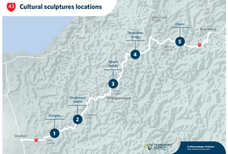
They will be erected off the road in rest areas or viewing places along the route at Douglas, Strathmore Saddle, Tahora Saddle, Tāngarākau Gorge and Otunui.
“The sculptures will give travellers an opportunity to break their journey while enjoying the stunning scenery and learning more about the history of the area,” project manager Sree Nutalpati said.
They would be a valuable addition to the region’s tourist offering, resulting in more visitors to the Forgotten World Highway and encouraging more tourism to the area, Nutalpati said.

“The improvements, along with sealing the road through the Tāngarākau Gorge, will make travelling along the Forgotten World Highway a safer, more viable and attractive option for locals and tourists alike, resulting in economic benefits for the region.”
The sculptures, or pou, recognise the rohe of mana whenua Ngāti Maru, Ngāti Hāua and Ngāti Ruanui and tell the story of the journey and explorations of the tūpuna Tamatea-Pōkai-Whenua and others.
The three iwi employed Taranaki-based consultant Tihei Ltd to create the five markers.
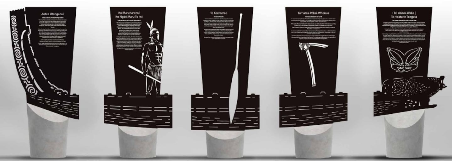
Designed by Rangi Kipa, the sculptures are made of water-cut corten steel and stand three metres high.
Each represents a section of Te Kāraerae, the waka belonging to Tamatea-Pōkai-Whenua.
The sculptures are expected to be in place by the end of the year.
Aotea Waka, Aotea Utanganui
The first section at Douglas represents Aotea Waka, Aotea Utanganui, the richly laden Aotea canoe. Under the command of Turi, the Aotea made the voyage across the South Pacific well equipped with the necessities required for settlement in a new land. Tubers, seeds, saplings, livestock and tools gave rise to the description Aotea Utanganui which translates as Aotea Richly Laden.
They continued overland to Taranaki. When Tamatea-Pōkai-Whenua arrived in the area, the crew of the Aotea were well established on the South Bank of the Patea River. Turi’s wife, Rongorongo and their children, a son Turangaimua and a daughter Tanerōroa, were also part of the crew.
Tamatea’s visit coincided with the birth of Turangaimua’s son, who was named Tamatea-Kopiri, Tamatea-Pōkai-Whenua’s namesake. Tamatea-Kopiri was an ancestor of Ngāti Maru. Turi’s daughter, Tanerōroa married Uhenga-Puanake who was Tamatea-Pōkai-Whenua’s uncle (his father Rongokāko’s brother). The iwi Ngāti Ruanui descends from this union. Ngāti Hāua, at the Taumarunui end of the Forgotten World Highway, also descend from this union through their ancestress, Hinengākau.
Maru – te ingoa kei runga i te whenua, the name on the land is Ngāti Maru
The second pou at Pohokura Saddle will speak of the origins of Ngāti Maru. Tribal whakapapa (genealogy) shows that the chief Maruwharanui was a 19th-generation descendant from Mōnoa, the founding ancestor of the Kāhui Maru. Maruwharanui’s daughter Tere-i-mātea married Tamatea-Kōpiri, the namesake of Tamatea-Pōkai-Whenua. In the generations that followed, the Kāhui Maru became the Ngāti Maru.
During the Taranaki Wars in the 1860s, the militia referred to this area as Ngātimaru Country. It was remote, rugged and branded as the ‘sanctuary for rebels’. Ngātimaru Country became the Ngātimaru Survey District (1877), the Ngātimaru Riding (1885) and the Ngātimaru Railway Station completed in 1915. These names have fallen into disuse, but the Ngāti Maru people remain.
Ngā Iwi o Neherā, ancient people
The third section will be placed on the Tahora Saddle. Centuries before the arrival of the Hawaiki people, the area was peopled by earlier tangata whenua, groups known as Kāhui Tara, Kāhui Toka, Kāhui Maru, Kāhui Mounga and many others. There were also groups with even older origins such as the Rako (albinos that Turi of the Aotea encountered), the Mohoao and the descendants of the ancestor Paerangi (from whom Ngāti Hāua trace descent).
Through intermarriage these earlier people were absorbed into the Ngāti groups of today and their identities therefore merged. On the Forgotten World Highway, the groups are the Ngāti Hāua, Ngāti Maru, Ngāti Ruanui – all have whakapapa from these earlier groups. Tamatea-Pōkai-Whenua encountered both Kāhui and Ngāti groups on his explorations in the area.
Tamatea-Pōkai-Whenua, explorer of land
The fourth pou at Tāngarākau represents the renowned explorer, Tamatea-Pōkai-Whenua, remembered by many landmarks in both the North and South Islands and on the Whanganui River. Local tradition remembers Tamatea as the son of Rongokāko, who brought the Takitimu waka to Aotearoa.
While on the West Coast of the North Island, Tamatea saw smoke rising from a mountain. His curiosity brought him up the river aboard his waka, Te Kāraerae, with a crew of 40. They stopped to cut (tānga) timber (rākau) to repair his waka and that place came to be known as Tāngarākau. He crossed overland at Taumatamāhoe Track and via the Whangamōmona Track, which today forms part of the Forgotten World Highway. A stream near the Taumatamāhoe Track, Manga-o-Apa was named for Tamatea’s son, Apa.
Tamatea’s arrival in the area is marked by a marriage between his daughter Hineue and Marukōpiri, the younger brother of Maruwharanui. He is especially remembered by their descendants Ngāti Tū, a hapū connected to both Ngāti Hāua and Ngāti Maru.
Arawa Waka – Te Hoata te Tangata
The fifth section will be placed at Otunui. Under the command of Tamatekapua, the Arawa waka made the voyage to Aotearoa and final landfall at Maketu, Bay of Plenty. The name of Ngāti Hauaroa (a principle hapū of Ngāti Hāua) originated with a Te Arawa ancestor of that name. Te Hoata II, considered to be a founding ancestor of Ngāti Hāua, migrated here from the lakes region of Rotorua.
During Tamatea-Pōkai-Whenua’s visit to the Whanganui River, an earlier tangata whenua group known as the Kāhui Tara peopled the land between Taumarunui and Te Tōtara (near Maraekōwhai). Intermarriage brought Ngāti Hāua into closer contact with the Kāhui Tara, particularly the marriage of a Ngāti Haua chief, Tapaka, to Te Aonawea.
Conflict arose in the following generation when Kimihia (Tapaka’s niece) became involved with a man named Mātaua. For some reason this angered Tarakāngiua (son of Tapaka). He killed Mātaua and when Kimihia gave birth to Mātaua’s son, the infant was also slain by Tarakāngiua. Kimihia raised a war party and the Kāhui Tara were defeated.
LDR is local body journalism co-funded by RNZ and NZ On Air


